Showing posts with label North Africa. Show all posts

Saturday, April 11

Morocco VIII: What's A Ksar and Why?

February 13, 2020
As always, click upon any image to enlarge it

Plate 64

The highway toward Marakesh from Ouarzazate winds through craggy southern slopes of the  High Atlas mountains cut deeply by the Ounila river.


Plate 65

A half hour into that Valley the town of Ben Haddous sits across the river from ruins of the Ksar Ait Ben Haddous. Every North African town has a mud and straw kasbah. This one, nestled against the mountain slopes, is among the most impressive. 

Plate 66


*****

Built around one of the steeply abrupt rocky hills that dot these vallies, Ben-Haddous's surrounded by an array of farms, mountains, and rivers. It’s believed that the town, as opposed to the Ksar, was established in 757 and that its founder, Ben-Haddous, still lies buried in his tomb behind this  decaying walled city. The site was also one of the many trading posts on the commercial route linking ancient Sudan to Marrakesh by the Dra Valley and the Tizi-n'Telouet Pass.

*****


Plate 67


*****

The Ksar of Ait-Ben-Haddous is an ighrem (fortified village) along the former caravan route between the Sahara and Marrakech. The word ‘Ksar’ refers to a large group of close-together kasbas (homes) and barns behind defensive city walls which are reinforced by corner angle towers and pierced by two baffle gates.

*****


Plate 68

*****

Unlike the town, but like Ouarzazate’s seraglio (See Morocco VI), the oldest ksar constructions do not appear to be earlier than the 17th century. However their structure and technique were propagated from a very early period in the valleys of southern Morocco. The site was also one of the many trading posts on the commercial route linking ancient Sudan to Marrakesh by the Dra Valley and the Tizi-n'Telouet 


Plate 69


Ksar Ait Ben Haddous is around 1,300 square meters. Made of red clay bricks, it has many long and narrow alleys tangling up in a unique geometric shape. Some structures are modest, others resemble small urban castles with their high angle towers and upper sections decorated with motifs in clay brick - but there are also community areas which include a mosque, a public square, grain threshing areas outside the ramparts, a fortification and a loft at the top of the village, a caravanserai, two cemeteries (Muslim and Jewish) and the Sanctuary of the Saint Sidi Ali.

Plate 70


*****

Plate 71


The earthen buildings are very vulnerable due to lack of maintenance and regular repair resulting from the abandonment of the ksar by its inhabitants.


*****

Plate 72

*****


Plate 73

*****
About 98 families lived in the Ksar until the 1940s. Nowadays, only five still live. there, most moved to modern structures in the bustling town across the river. The large houses in the lower part of the ksar however, with well conserved decorative motifs, are regularly maintained. Workers return daily however to shops that serve the entire area’s lively-hood: tourism and the movie makers from Oouarzazate.


Plate 74

*****

Plate 76

*****

The architectural style has adapted to the climatic conditions all in harmony with natural and social environment configurations.  The inclination during restoration to introduce cement has so far been unsuccessful. Only a few lintels and reinforced concrete have escaped vigilance, but they have been hidden by earthen rendering.

Plate 77
Note the graffiti on the front of this shop. This was a set for the movie Gladiato


*****

Plate 78

*****
Scholars conclude that Ksar of Ait-Ben-Haddous represents the Berber culture of southern Morocco, which itself has become vulnerable as a result of irreversible socio-economic and cultural changes.


Plate 79

*****

Plate 80
Up next - Morocco IX: Marakesh 


Sunday, March 29

Morocco VI: On The Road


Circa. February 11-13, 2020
As always, click upon any image to make it BIG!

Morocco appears to be a place of dueling paradigms. As I’ve written, it’s a highway along which cultures moved each moulding what they’ve found along their way. It’s customs are a gift of its landscape. Today Arab/Muslim totems form a shell that’s kneaded by current and historic European and African ways.

Virtually everything in life is a product of cultures and customs coming from very different places. That tradition appears to have created opportunities for Morocco to drill a hole into barriers to change. Much like Turkey, which has acted as similar bridge for mass migrations, Morocco’s secularized its way of life particularly in its modern cities. 

What happens when two historical cultures collide? 

How much can a tourist learn about Morocco through a bus's window? At rest stops? Lightening tours through road markets or tourist stops? Or quick-walking the streets of a town to leg-stretch? Do we learn or merely clot feelings together into a harebrained heap? I dunno. Let's see.


It's a nine hour bus ride from Erfoud to Ouarzazate back down through the Atlas Mountains and across the cultivated Draa valley. Verdant? In reality, much of Morocco is desert. But snowy peaks collect on mountain tops and then melt to fill some creeks and underground aquifers and there's sufficient rainfall near to the coast to supplement the runoff. 

Millennia ago Moroccans learned how to tap those underground flows, unplugging them with wells and pipes then letting gravity irrigate fields of wheat, olives, dates, spices, nuts, fruits, and tomatoes. Yep, you've noticed in the images so far from this shoot, how similar Morocco looks to the U.S. Southwest, right? 

See Hank Rettew up there in his Clint Eastwood pose? Actually the engineer was studying a deep well whose weathered support-apparatus looks eerily like the ruins of native American workings in Nevada, New Mexico, Utah, or Colorado. How come? Shrouded in prehistoric mist, lies an explanation.

Plate 43

Look at any world map and you'll see how South America fits neatly into the African coast line. Geologists tell us that both the Americas, Europe, and Africa were once joined into a vast Oceania that ripped apart to ride upon plates to their present global positions. Which might mean that Africa's upper western tip nestled neatly into what's now the Gulf of Mexico so that the geologies of the two regions match. Look at the image above. Can you imagine 1950s Western movies  filmed there filled with cowboys, stage coaches, and teepees? 

Similarity of climate and geology have lent to the exploitation of identical building materials - largely adobe rectangles  - which dot both the North American Southwest and the rugged countryside of Morocco. Geologists love Morocco... and so do fossil collectors since much of this area was, as was the U.S. Southwest, undersea during the wanderings of tectonic plates. 


Plate 44

The rugged countryside allows for hard-scrabble subsistence and larger estate farming: Many feeding country markets along the route or selling their handcrafted rugs and jewelry through a valley of hooded men.

Plate 45

Plate 46
Plate 47

Here's where the Sahara inexorably encroaches along the valley's edges. It’s where nomads stop for a while to raise donkeys and some livestock. Does this guy wonder each morning if this sunrise will mean the last of rainfall here on the edge of land's end? Hmmm...

Plate 48

The immense plates continue to shift beneath Moroccan’s feet - quaking down the adobe villages. The waves leave behind eerily empty bands of structures surrounding new, hopefully, sounder construction. These abandoned strips are like rings on a tree marking the times between vicious quakes which reproduced disciplines of scarcity. 

Plate 49

The new walls though are built around memories of ancient Berber and Arab design. As if a lost-wax method was used to pour the new around a mimesis of history or legend. And the core of the matter is always about changing customs. 

Plate 50

For example, notice how the Hotel Rosa is designed around the Moroccan style, yet it lacks any Arabic writing.  Now, look carefully at The Komar Lounge up there. See the signs above each doorway. Intriguing how twin cultures mesh here, yet don’t.  Is there a wall between the two interiors? I guess to the left they eat, drink, dance and be merry.... While on the right they eat and be merry? Morocco's - a place between - whose people have adapted since way before Carthage ruled them.

Plate 51

It's continually restructuring atop the leavings of the past. Here ancient ways meander through modern tag sales.
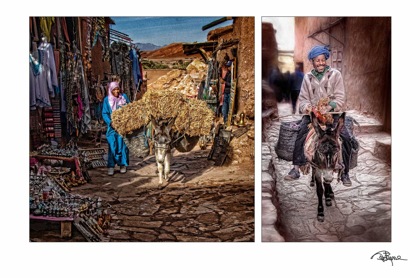
Plate 52
One thing's clear on every Moroccan street. Customs are a residue of coping, and men are allowed to transition more quickly than women. 

Plate 53

Are there lessons from the other side of a bus's windows?  More likely there are only feelings which we filter through whatever it is we bring to a place.

Coming soon: Morocco VII: Ouarzazate: Africa’s Hollywood


Monday, March 16

Morocco Images III - Volubilis

February 8, 2020
As always, click upon any image to make it BIG!

Between the royal cities of Rabat and Fez there's a spot... A dig into the shadow of the ancient ways beneath Morocco's dirt. They've drilled sort of a manhole... Oops... person hole...  down into the historic foundation of this causeway nation... This bridge which untold millions have crossed between the European and African continents. Okay, historians make the past as unpredictable as the future. It's what they do. Still, here's a spot where Morocco's shoveling into all of our histories.

Our Moroccan Expedition was gamely produced by Gib Armstrong who hauled us both ways
storing us neatly into the buses, planes, and hotels that make touring bearable.
Plate 11

Once upon a time the swath of North Africa framing the Mediterranean Sea was Rome's breadbasket. It was the richest verdant strip of land known to the history of their moment. From the prosperous town of Volubilis in what's now Morocco to the fat and burgeoning Egyptian capitol of Memphis at the mouth of the Nile basin, African farmers fed the vast empire's belly with fruit, olives, wine, meat, and grain in astonishing quantities. They also bred the "wild" animals for Roman colosseums throughout the empire. It was a never-again rivaled regional miracle of cultural, military, political, and agrarian engineering.

Arriving around 45 AD here between the Khoumane river and a shallow verdant slope of Zerhoun mountain, Rome's legions muscled into a sleepy Berber, Mauretanian, Amazigh, and Carthaginian village. They stayed in this place, renamed Volubilis, until either those legions lost their muscle or feisty locals regrew their own in the year 285.

Detail of Volubilis' Trimuphal Arch
Plate 12
Dark ages crushed the town that once housed 20,000 prosperous Romans. They stripped its marble-coated buildings, even crushing the underground piping that carried water to structures, much of it heated to generate radiant warmth beneath floors in cold nights and wintery days. Gone too was the system of sewers that drained the city's refuse. Over the centuries vandals, clerics, and politicians quarried the structures of shiny skins, stones, and bricks to make their own public buildings, mosques and churches, leaving naked bones like that detail above of Volubilis' once grand arch.

Plate 13

But still locals lived in the ancient homes and tread the old village stairs.

Plate 14


For centuries the new Christian religion and later the Muslims worshiped within Roman public buildings they converted into churches then mosques.

Frank & Barbara Pinto pose midst the vast public building
its columns now supporting nests of great white cranes.
Plate 15

Plate 16

The might of Rome still whispers... no shouts is a better word... Yeah, Roman architects and builders routinely created massive works without power tools, elevators, or bulldozer brawn. 

They used a lot of labor, but remember this city had only 20,000 people (including slaves), about the population of  Columbia in Lancaster County, Pennsylvania --  perhaps even fewer . And most of those were there to engage in or support farming. How'd they do that? How did they cloth, feed, house, and support such a large percentage of craftspeople who were not contributing to the productivity which brought wealth from trade to this village?

The mosaic floors of the Volubilis mansions and public buildings showed a rich depth of
highly skilled artisans were available to feed the town's ambitions.
Plate 17
A microcosm of Roman glory, this tiny place off on the western edge of Rome's African empire stood until a massive 1750s Portuguese earthquake some 500 miles to its north jolted everything down. It leveled the last, mostly abandoned, buildings and left it forgotten until the 1920s when French archeologists began its rediscovery. 

Plate 18

The Kingdom of Morocco continues to piece the ancient puzzle-place back together. They're repiling the rocks to remind visitors of ghosts lurking in memory's mists. People who managed to somehow stave off the darkness from 45 till 285AD. Dreamers who reached from this tiny place to the spectacular metropolises of the Nile to create a sparkling necklace of farming wealth that dangled about Rome's southern neck. 

Plate 19

What's left of the children's screams, barking dogs, hard men in sun-bleached tunics? Where's the stench of horse and donkey traffic lugging rackety carts along the arrow-straight Decumanus Maximus the great avenue connecting the city's main gate with and through this once magnificent arch? Squint into the dazzling African sun and that rock pile becomes different... an abstract... a painter's feeling of...

The writer J.P. Hartley said, "The past is a foreign country, they do things differently there."

And there's that person-hole through the arch's center back to where ancients might still do things differently. 


Coming Next: Moroccan Images IV - The mysterious royal city of Fez.


Sunday, March 1

Volubilis Rocks

c. 85AD: Detail of the Volubilis Triumphal Arch


Niche marketing? Hmmmm... Howzabout another title, "Volubilis Is Stoned"? Or was... 

These ruins were originally clad in marble which was later quarried to clad churches, mosques and public buildings by the Berbers, Christians, and Muslim over
succeeding ages.

Oddly this city continued to stand, inhabited, until 1755 when an astounding earthquake some 700 miles to the north in Portugal, buried it. Since the 1912 the French and now UNESCO have slowly uncovered and rehabilitated some of the ancient ruins revealing the great olive-growing wealth of this Western capital of Rome's breadbasket in Northern Africa.  

GEEK STUFF: Hand held Canon 7D MkII, Canon EFS 17-85mm (f4-5.6), ghastly mid-afternoon February lighting under cloudless sky.  Remember, these are the bones of construction once boarded over in marble. The construction/engineering of the city was high by modern standards with extensive underground plumbing, sewage, and radiant heating beneath the homes and streets. For about three centuries none of this infrastructure showed to the city's visitors or residents. It must have dazzled beneath the North African sun.