Showing posts with label Puerto Chacabuco. Show all posts

Wednesday, February 27

Patagonia 5: Puerto Chacabuco - Soft Scrapple


For details, click on any image...
It's 291 nautical miles from Montt to our second
stop at  Chacabuco south through the Golf of Corcovado.
It's about a day and a half by ship between the red pins.
Puerto Chacabuco is a relatively new port city. In 1991 a savage wilderness fire and the eruption of nearby Mount Hudson volcano silted the Aisén river and blocked access to Puerto Aisén which caused the construction of a new port in the sleepy village of Chacabuco some 10 miles south of Aisén. Transition's fattening up Chacabuco and its population of 1,243. 

However, the town's location along the far side of the Aisén river is magnificent. 

At sunrise on Tuesday 1/22/19 we awoke to this view from our balcony on the
ship's port side with Chacabuco visible (below) from the starboard.
Daytime temperatures dropped about fifteen degrees, on average from Santiago mid-day 90 degrees to Puerto Montt and another ten degrees in Puerto Chacabuco. The town's weather is wet much of the year, but in mid-summer-January that still left us wearing heavy jackets over long sleeves in the port's morning which we ditched by late afternoon.

Joe & Mary Mayberry, Gib & Marti Armstrong and
 my wife Rita model Chacabuco January mid-summer fashions.
BTW, that's our Norwegian  Sun anchored to the right.

On the other side of the river from the image above, Chacabuco sits
 in a river valley and is beginning to sprawl as a result of
its replacement of Aisén in 1991 as the region's major port. 

And what's to do in Chacabuco? Well, just about nothing. So we engaged an old VW bus-like ride to visit the new National Simpson River Park.

As you can see, the topography is rugged and mountainous.
Our bus had an ancient low gear which left us expecting to push.
The trip did reveal the life style of people living along rural Route 240 as well as structures in both Chacabuco and Aisén.


Generally the people are NOT poor. Rather they live in tidy, secure, and comfortable structures in a rocky countryside dotted by small livestock farms. NOTE the canted metal roofs in all of the structures above. Why? Tons of snow of course. Note also the lack of foundation shrubbery which is always destroyed by the collapse of snow upon them from those roofs. This is a challenging place in winter.

 The last President of Chilé kicked off an expensive (and not overwhelmingly popular) series of national parks. One of the newest is the Parque National Rio Simpson. Which features, well, some wild flowers and the Simpson River. 

The Simpson's a nice mountain river, and well, ho-hum. Perhaps if you are a Saudi
this is inspiring. And certainly to fly fishers it's inspirational. I'm neither. Seen one river,
seen 'em all? Well no, but this one is pretty average even within its mountainous setting.

The trip up to the park though wound cooly through valleys alongside a rushing stream fed by waterfalls dropping from the peaked walls of the old Pioneer Trail.

Note, just to the right of the base of the lower waterfall. See the guy? I left him there 
to put the height of these glacial fed falls in perspective. Rain  returned as  I teetered
atop the two-lane highway bridge's  railing to grab this shot above the stream. 
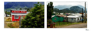
In the very center of the port sits Radio Chacabuco there on the right. It was hidden behind a few downtrodden  
shops but worth the effort. See the dirt road? What you can't see well in this painting without blowing it up is the line of new  construction there between the mountain base and the field at the road's end. 
A Levittown development's happening there with perhaps a hundred homes going up. Chacapuco's about to change as its expanding port juices economic activity. This image captures the transition right before it happens. And, of course it's just the painting to bring country life to a chi-chi Santiago, New York, Lancaster, Atlanta, or Viennese up-market condo, right?


Chacabuco caused one of us to wonder if this is where you flee to escape the rest of the world. Near-antarctic winters are intense and even the summer's are challenging. But the farms and port apparently create jobs and incomes sufficient to live snugly with the weather, volcanos, and earthquakes. It's not hard scrapple, no... but definitely soft scrapple. 


Saturday, February 16

Patagonia 4: Volcano Orsono


North and East of Puerto Varas we drove some 15 miles away and up  from Lake Lanquillue to The Vincente Perez Rosales Chiléan State Park and the Petrohué Falls.
These are a series of chute waterfalls grinding paths through ancient basaltic lava blasted from the Osorno Volcano that sits between two lakes, the largest, Llanquihue supporting the resort towns discussed in the last post. The water decanted in the lake is clear with a distinct green hue but the cascading torrents from melts of Volcano Orsono carry sand and silt which has ground the walls of its deep crags into glassy surfaces.

Volcano Orsono, Chilé

Chilé's most active volcano: Orsrono is a symmetrical and glacier-capped peak which has produced massive lava flows. It's blown from both the summit and from flank vents and fissures along the left face of the image above. Many of its eruptions over the past 14,000 years have created astonishing pyroclastic flows and surges while explosions from its tip have effected world-wide climate effects.

Took Rtes 5 then 225 up to Petrohué Park then hiked


The cone of the mountain sits above a roughly 250,000-year-old stratovolcano whose caldera is deeply glacial scarred and mostly buried today. Interestingly, scientists have measured pronounced increases the size of Osorno's glaciers as they have with glacial growth throughout Patagonia and Antartica. While this glacial expansion's received little media attention, meteorologists have recorded increasingly colder Southern Hemisphere temperatures over the past three or four decades. It's a puzzling activity which astronomers have noted on Mars where northern ice caps appear to be contracting as its southern caps expand. 

Vocanic Danger Zones! Signs found throughout the lake districts, this one explaining
  the various warning levels  and evac-routes posted in the media and along roadway billboards.
So at about 2:15 on the afternoon of Tuesday, January 21st, we hiked up the rocky park trails beyond the tree-line toward the majestic finger of Orsono to a spot which allowed both a view of the gushing chutes and their pristine glacial source thousands of feet above.

Here's the miles-long trail that brought my camera (and virtual easel)
to the base of Orsono and the cascades gushing from its summer run-off.
GEEK STUFF: The photographer's nightmare... or daymare? Sun blazing through almost cloudless skies during the day's hottest hours. Both contrast and glare got cranked beyond 10 with highlights burnt crispy and shadows darker than Satan's fantasies. YIKES! What to do. I tried HDR shooting to bracket exposures then blended them together in Photoshop, digging into both the whites and darks, but still the images wouldn't give up their secrets. So, screwing a polarizer over a neutral density filter to darken the sky and pop the whites I got an image that allowed me to  tease out the impression that this Monster blow-hole burnt into my feelings. 

Failing to pop an acceptable photograph from the mid-day sun's broiling, here's my imagination's take on Orsono's cone and it's tributaries which form the headwaters of Chilé's Petrohué river. 

A south-western painting of Volcano Orsono and it's glacier-blue/green
waters gushing along the explosive Saltos Del Petrohué.